Astronomical Cartography Organization
More actions
Astronomical Cartography Organisation (T.A.C.O.)
Astronomical survey and mapping organization
Space And Navigation Solutions foundation
2665
51,000 active members
- Solar System mapping
- Interstellar navigation mapping
- S.P.A.C.E.E.N.G.I.N.E. software development
- Scanning and mapping the sky and Solar System
- Producing space maps for education and navigation
- Maintaining the S.P.A.C.E.E.N.G.I.N.E. database
Public database and educational outreach
The Astronomical Cartography Organisation, otherwise known as T.A.C.O, is a group stationed in the Solar System dedicated to scanning the skes and adding the info to a publicly accessible database. This organisation also produces maps of the Solar System, showing what certain regions are dedicated to. T.A.C.O. also contributes to education, allowing their maps to be used in classrooms. Another thing produced is maps of interstellar space. Assisting interstellar ships through long voyages, their maps of the cosmos can be uploaded to a navigation computer allowing for an autopilot to guide a ship all the way. These interstellar maps are also public.
The database that T.A.C.O. information is uploaded to is known as the Space Program And Classroom Education Endless Newtonian Gravitational Integrated N-body SpacEflight (or S.P.A.C.E.E.N.G.I.N.E.) which can be fed into a program allowing for the user to browse an interactive 3D map of the universe, and as the second half of the name suggests, flight simulation for space programs, classrooms and home users. Branches of this program exist, including one that adds a procedural generation feature, filling in unknowns with imaginary bodies. S.P.A.C.E.E.N.G.I.N.E. is integral to the flight training of interstellar captains willing to undertake such a risky journey, and is the most used software by space agencies as of 2742.
Currently, T.A.C.O. has 51,000 active members and 1,500 active telescopes around the solar system and en route to distant star systems.
T.A.C.O. was founded in 2665 by the Space And Navigation Solutions foundation to provide an easier alternative to the existing closed-off databases at the time.
Space Maps
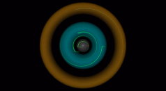
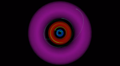
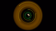
Grey: Dyson Operations
Brown = Mining Operations
Cyan = Inhabited Regions
Blue = Long Term Tourism
Green = Nature Reserve
Red = Millitary Operations
Magenta = Government Operations
(Earth-Moon) Cyan = Geosynchronous Orbit
(Earth-Moon) Purple dots = Lagrange Points
-
 Inner Solar System
 -
 Outer Solar System
 -
 Mars
Mars -
 Saturn
 -
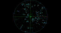
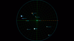 10ly zone around Sol
 -
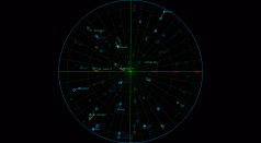
 50ly zone around Sol. These stars are the furthest accessible through reasonable travel times.
 -
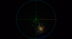
 Stars in a 300ly radius. These stars can only be accessed through warp travel.
 -
 Our region of the Galactic Arm. These areas can only be accessed through generation ships.


